The Brazilian "Terrenos de Marinha" and the Relative Sea Level of the Year 1831 at "Praia do Pulso"
A. R. de Mesquita*, D. Blitzkow**, C. A. S. França *, J. L. A. Trabanco***, M. A. Corrêa * & M. Q. Monteiro*
** EP-USP, *** FEC-UNICAMP.
*Instituto Oceanográfico da USP. Cidade Universitária. CEP 05508-900, S. Paulo.SP. Tel 3091 6564, E-mail ardmesqu@usp.br.
Abstract
The Relative Sea Level of "Praia do Pulso" (PP), of the year of 1831, localised between the island of "São. Sebastião", and the city of Ubatuba, in the State of São Paulo, Brazil, as established by the Brazilian Law Number 9760 of 1946, has been estimated and materialised. The estimate followed plausible hypothesis on the global relative sea level variation since 1831 up to the present, measured in the port of Brest, France, in the port of Cananeia, Brazil, and from the global estimates of IPCC (Intergovernmental Panel for Climate Change) of UNESCO. The retro-prediction, allowed the demarcation of the "Terrenos de Marinha" (Union Sea Land property) in PP, along the terms of the Law. The accuracy of the procedure, based on the assumption of same sea level, for transferring the long term sea level from the IOUSP station of Ubatuba to PP, was assessed by parallel work of geometrical levelling referred to the national IBGE (Brazilian Institute of Geography and Statistic) geodetic network. The levelling were also extended to the bench mark of "Praia do Cançandoca", (also "Cassandoca"), where the first IOUSP levelling measurements of the area were taken in 1958 during the Geophysical Year. The motivation, the hypothesis and the methods (Brest, IPCC and Cananeia ) utilised are again described with a short historic review of the Brazilian "Terrenos de Marinha". Results indicate that the "Terrenos de Marinha" in Praia do Pulso are well within the limits of the beach,. determined according to the law Nr 9760 and stress the need for reactivating the national network of sea level gauges, bearing in mind the clear evidences of present days increase of Relative Sea Level, along the entire Brazilian coast, and the consequent necessity of defining legal norms for their adequate utilisation to face the present days global warming and its consequences to the properties of the Brazilian Union of States.
Introduction
This work is a follow up of previous results obtained in Barra do Una by Mesquita et al (2002) and goes along the difficulties related to the federal regulation defined in the Law 9.760 of 1946, for the legal determination of the land property of the Union. As in Barra do Una, there is the legal need to comply "ipsis litteris", with the terms of the Law and for that is necessary to know w the Relative Sea Level of year 1831 in "Praia do PULSO". Fig. 1.
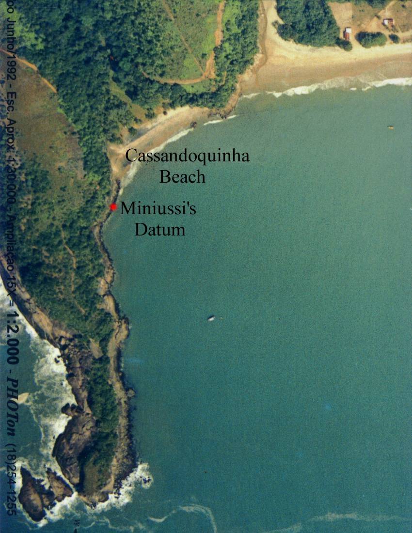
Fig 1 - View of "Praia do Cassandoquinha", (also Caçandoquinha)on the left side, indicating the Miniussi´s bench mark of 1958, ( RN2). On the right side is the nearby "Praia do Pulso", showing the positions of the tidal staff and the datum (RN1). Pulso 1 and Pulso 2 are the points used for levelling and geo-referencing of PP. They were all referred to the IBGE datum of the port of Imbituba. Photos from Dr Robert Nicol & Dra Vera Nicol,( private communication).
The problem is of difficult solution in the present days as, although the records of 1831 obtained in the Harbor of Rio de Janeiro are well kept in the Museum of the Directory and Navigation of the Brazilian Navy in the city of Niteroi, State of Rio de Janeiro, as far it is known, there is no information about the "datum" relative to which the sea levels of 1831 were referred to . For this reason the mean sea level of 1831 of Rio de Janeiro that is mentioned in the Law of 1946 as a National reference, for the purpose of legally fixing the land limits of the Nation, can not be materialised in the Harbor of Rio de Janeiro and it is not possible the application "ipsis litteris" of the Law to any part of the coast.
With aims of assessing the method used in the solution of the problem, given by Mesquita et al (2002), a short review of the term "Terrenos de Marinha" is given ; a description of the Praia do Pulso; a description of measurements taken in the Pulso beach; the levelling equipment ; the AOTT sea level utilised at Ubatuba Research Station; a description of the instruments used in Praia do Pulso; the methods used for the obtainment of the Relative Sea Level of Praia do Pulso and the obtainment by retro-prediction of the Mean of High Waters of 1831 are also given. Results also indicate that the methods that were used are adequate to the solution of the problem leading to a Discussion in which are posed to reason, the Global Warming of present days and the need for re activating the national net work of sea level gauges and the related services to face its effects on the sea level rise in the Brazilian coast.
The Union Sea Land Property - (Terrenos de Marinha)
First mention of governmental acts taken by Portuguese authorities regarding the regulations for building along the beaches appeared in 21 of October of 1710, through the "Ordem Régia" from the Portuguese Crown telling the Governor of Rio de Janeiro to inform about the houses built along the beaches of the Town. SPU (1999).
The first measurements of sea level in the Land of Santa Cruz occurred in the Guanabara Bay, near to the open bar to the Atlantic during the years of 1731 and 1782, by Sanches Dorta, a Portuguese astronomer of that time.
During the period when there was the installation of the Portuguese Crown in Brazil, in 1808, a national Decree of 21st of January of 1809 urged the "registration of the properties of the "Gamboa" and "Saco do Alferes". Beaches that were proper for building warehouses and piers"; a "Aviso" of 18 of November of 1818 stated that "15 "braças" from the line of water and along its border are reserved to the public service and everything that touches the sea water and increases over it is a property of the Nation".
A Decree of 13 of September of 1820 gave attribution to the Navy to concede any portion of the beach in all ports. During the First Kingdom, soon after 1822, a Law of 15 of October of 1831 fixed the resources and the expenses, the budget for the fiscal years of 1832 - 1833 and a Law that particularly dealt with the "Union Sea Land", giving them, to the local Municipalities and allowing the Presidents of the Provinces to register and establish the "forum" for the "Terrenos de Marinha". The definition of "Terrenos de Marinha" was given through the Instruction Number 348.
The first systematic measurements of sea level heights, that were recorded, occurred during the year of 1831. They were taken with the objective of defining, on the ground, the mean sea level height for the harbour of Rio de Janeiro. There are no news that these measurements were further taken for a longer period.
In 1889 the Republic of Brazil was proclaimed and new horizons were opened in the political scenario of the ancient Isle of Vera Cruz. However there was nothing to indicate the presence of changes in the contributions which the Federal Inspectory of Ports and Channels that maintained the stations of the main Brazilian ports from the river "Chuí", in South, to the river "Oiapoque", in the North.
In the scenario of the New Republic there were the progresses in the organisation and operation of a set of permanent stations for measuring the sea level along the nearly 8 thousand kilometres of the Brazilian coast. There was the installation of sea level gauges in the following stations: in the city of Rio de Janeiro in 1905, in the city of Fortaleza in 1910, in Santos in 1920, Pelotas in 1930, Laguna in 1906, São Francisco do Sul in 1923, Florianopolis in 1923, Itajaí in 1922, Paranaguá in 1928, Pelotas in 1928 and Vitoria in 1917, Salvador in 1928, Aracaju in 1935, Recife in 1935, Natal in 1939 and Belém in 1935.
In such places the records were read for the maxima and minima values of temperature and atmospheric pressure, by the precursor of Portobras. Company of ports of the new republic that cared for the implantation and the operation of the permanent stations of sea level.
The University of São Paulo founded in 1934, installed in the 50ths and still operates through its Institute of Oceanography, the permanent stations for measuring the Relative Sea Level in the Research Stations of Cananeia and Ubatuba.
The Law 9.760 in its Section II, article 2 that deals with maters of Properties of the Brazilian Federation of States determines that the "Terreno de Marinha" should have to be measured relative to the Mean Sea Level of 1831. The sea level records for its determination are presently in the Museum of the Directory of Hydrography and Navigation of the Brazilian Navy, Niteroi, Rio de Janeiro, however, there is no information about the datum to which the records were referred to in the Harbour of Rio de Janeiro.
The Praia do PULSO - (PP)
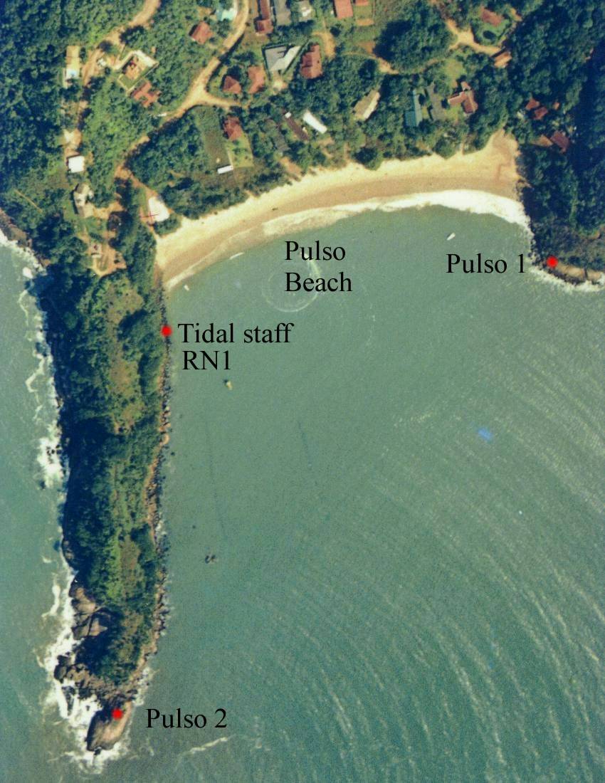
The "Praia do PULSO" (PP) (Beach of Pulso) is along the littoral of the State of São Paulo and part of it is shown in Fig 2, where there is the Rio do PULSO and the nearby Caçandoca Beach.
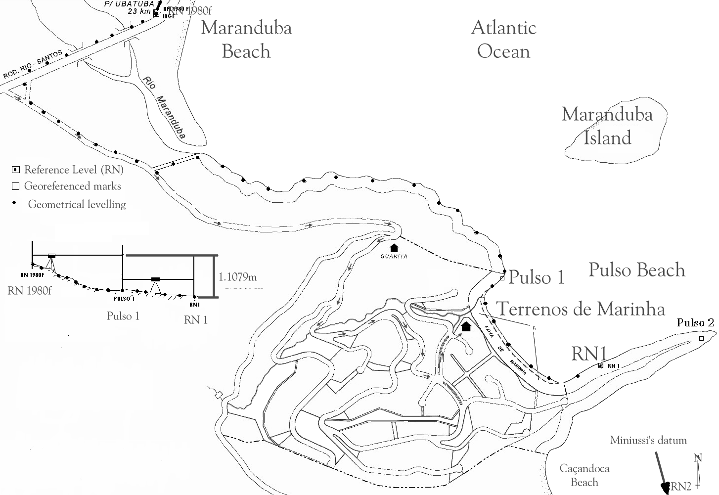
Fig 2- Praia do PULSO with the indications of locations where the datum is fixed for geo-referencing and positioning - (PULSO1- PULSO2-, RN1) for sea level measurements and the Caçandoca Beach where the levelling work was also extended to previous levelling work during the Geophysical Year of 1958,(RN2), by Miniussi (1963).
The Geo-referencing
The geo-referencing was made with the GPS system Fig 3. The TRIMBLE system model 4000 SSI with frequencies L1, L2 and codes C/A and P. It was used the software GPSURVEY that allows the processing of stations by the static method. The ephemerides transmitted, based on the Brazilian Net for continuous monitoring (RBMC)- UEPP and PARA, respectively city of Presidente Prudente SP. and the city of Curitiba, PR. The stations were materialised via marks in the concrete and bronze metal laminas in the ground ( PULSO1) and fixed on the rocks (PULSO2), as indicated in Fig 2.
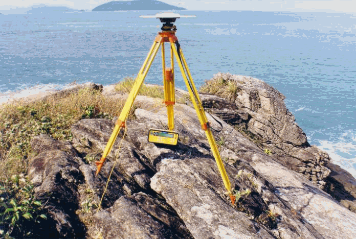
Fig 3 - Aspects of measurements with GPS in Praia do PULSO.
TABLE I
| STATION | EAST | NORTH | ORTOMETRIC ALTITUDE |
| PULSO 1 | 477561.6563 | 7395084.16398 | 1.4240 |
| PULSO 2 | 478114.0284 | 7394941.54819 |
UTM SYSTEM OF COORDINATES - METERS - RELATIVE TO SAD 69
Table I shows the results of the use of GPS for localising the Pulso beach in the planet. Positioning is given in Universal Topographic Units (UTM) expressed in meters which have origin in the meridian of 45 W and latitude 0 degrees.
Measurements of Relative Sea Level
The measurements of relative sea level were taken with an AOTT gauge of the Research Base" Clarimundo de Jesus" of the IOUSP in Ubatuba (UBA); of a German manufacturer, Fig 4, it has produced sea level data for the last 50 years in an almost continuous data set. The equipment and its first and original datum are described in the publication Tides and Tide Gauges of Cananeia and Ubatuba, Mesquita e Harari (1983).
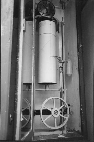
Fig. 4 - The AOTT sea level gauge of the Research Station Clarimundo de Jesus, Ubatuba, - Instituto Oceanográfico da Universidade de São Paulo.
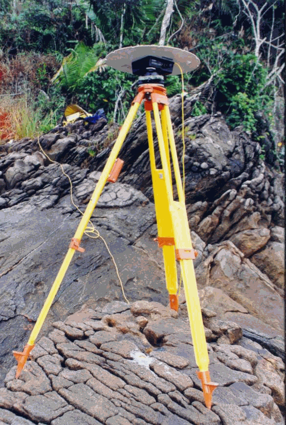
Fig. 5 - Land mark PULSO1 of as indicated in Fig 1.

Fig 6 - Visual Measurements taken with a Tidal Staff at RN1 in Praia do Pulso
Geometrical levelling
Geometrical levelling was referred to the mean sea level of the port of Imbituba, sea level adopted by the Brazilian Institute of Geography and Statistics (IBGE), as the national datum origin for levelling work around the country, replacing the 1831 mark of Rio de Janeiro that is not known yet its whereabouts. Figure 2 shows the distribution of the main points chosen for levelling of PP and Fig 7 shows the main points for the Ubatuba research station.
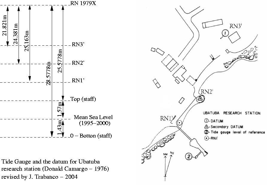
Fig 7 - The Mesquita & Harari (1983) levelling - revised by Eng. J. Trabanco (2004) after the rebuilding work made on the pier where are tide gauge's house and the tide measurements facilities. Numbers on the left side of the figure represent the vertical distances to IBGE's 1979X level of reference. The vertical distance of RN1' to the top of the tidal staff, in its new position, is 0.415 m
Levelling of Caçandoca Beach
Levelling of the datum (RN2) (Fig 1), fixed in Caçandoquinha beach, Miniussi (1963), Ochippinti et al (1963), during the first interdisciplinary campaign made by the Institute of Oceanography of USP, in the Geophysical Year, 1958, was compared by means of the geometrical levelling of "Praia do Pulso". Results revealed that there was no significative changes between the two levellings and allowed to refer the Caçandoquinha datum to the mean sea level of the research station of Ubatuba and its geo-referencing, following the sea levelling as indicated by an arrow in Fig 2. Its orthometric altitude was 2.202 m with co-ordinates 477347,1835 East ; 7395640,917 North.
Levelling Results
Results of the levelling work are summarised in Figure 8 for PP and Ubatuba, showing the levelling measurements expressed in meters and the mean sea level of the period of the field work (30/05 - 03/06/03), where simultaneous measurements of sea level heights, were taken in PP and Ubatuba.
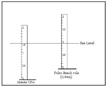
Fig 8 - Mean Sea Level of 5 days of measurements in Ubatuba (1.51m).and Pulso (0.49m) were taken as representing the same sea level as the places are relatively closed.
Sea Level Measurements
Measurements of PP were taken at 15 minutes interval, by visual reading of the tidal staff with readings in meters, decimetres and centimetres, for 5 days, for 12 hours in each day, from 6 in the mornings to 18h in the afternoon. The recorded mean values of sea level of the places were respectively (0.94 m) and (1.51 m) for PP and Ubatuba, giving a difference for their zero values to the mean sea level of the period of 0.57 m.
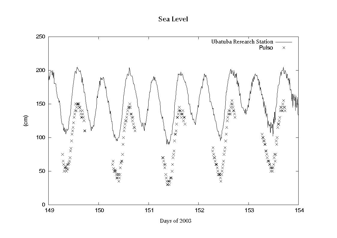
Fig. 9 Measurement in Pulso Beach (crosses x) and Ubatuba tide gauge (continuos line)
By assuming that the sea level of both places are physically the same one, (i.e. would not differ from the geometrical levelling), bearing in mind the relatively close places they are, Fig 10 was produced by adjusting the sea level of both places in the figure . As can be seen the sea in both places have synchronous variation with a slightly larger amplitude in PP than in Ubatuba. The rat of amplitudes PP/Ubatuba was calculated as 1.02.
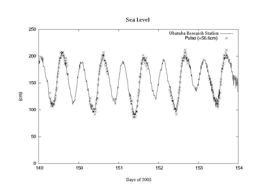
Fig. 10 Measurements of Pulso (x) and Ubatuba (continuous line) referred to de same local sea level
This rate value was used to estimate the mean for the year 1831 of the sea level heights of the syzigies in PP, from the knowledge of its corresponding values in Ubatuba, obtained by retro-prediction, using the harmonic constants of Ubatuba given in Mesquita and Harari 1983 and applying the procedures given in Mesquita and França (2001) for the retro-calculation.
The effectiveness of this procedure was tested, by making the prediction of the sea level of Ubatuba actually recorded during the period of the field work and comparing their values as can be seen in Fig 11. Measured values of sea level are shown as the darker curve and the lighter one indicates the predicted values of sea level. From the comparison of the curves one sees that they are very well synchronous and the differences in amplitude in some periods are due to the so called atmospheric tides.
In Fig 11 are also indicated the retro-predicted mean level of the syziges
of 1995 to 2000 as (0.334![]() 0.005 m) and the mean level of the syziges for the period as (0.332
0.005 m) and the mean level of the syziges for the period as (0.332![]() 0.007 m), obtained from the measurements.
0.007 m), obtained from the measurements.
To estimate the corresponding long term sea level values for PP is necessary first to subtract 0.57m from the above mean, 1.43, which gives 0.86 m and then add this mean to 0.332 multiplied by 1.02 giving 0.338 m, resulting from the addition, the present day’s value of 1.198 m , for the mean of syziges of PP relative to the zero of the tidal staff as shown in Fig 6.
To estimate the long term value of the mean sea level of 1831 in PP is necessary to estimate first, how far is the mean sea level, now days, from the position it were in 1831. It is well known that the global sea level has risen since 1831 in the tropical and subtropical areas of the globe that includes the southern coast of Brazil. To produce this estimate three hypotheses are considered for the rate of increase of the global relative sea level since 1831 till now, as such:
1) - that sea level of PP has varied from 1831 till now at the same rate of the port of Brest in France, that is one of the few ports of the world to have recorded sea level since the year 1807. The long term sea level of Brest of 2003 can be calculated from the actual series of mean annual data of Brest that can be found in the address http://www.pol.ac.uk/psmsl/programmes/gloss/info.html. The rate of increase of sea level in Brest is 9.6 cm/100years, which gives for the period 1831 - 2000 an increase of sea level of the order of 71 x 9.6 cm/100years = 0.71 x 9.6 = 6.8 1cm. In order to know, where in the beach, would be in PP the syziges sea level of 1831, this value must be diminished from its present value, 1.198, giving 1.130 m relative to the zero of the tidal staff shown in Fig 6.
2) - that sea level of PP has varied from 1831 till now at the same rate of the port Cananeia in State of São Paulo, Brazil, where sea level has been recorded since the year 1954. The long term sea level of Cananeia of 2000 was calculated from the series of mean annual data of Cananeia as in França (2000). The rate of increase of sea level in Cananeia is 40 cm/100 years, which gives for the period 1831 - 2000 an increase of sea level of the order of 71 x 40 cm/100years = 0.71 x 40 = 28.4cm. In order to know where, in the beach, would be the syziges sea level of 1831; this value must be diminished from 1.198 giving 0.914 m.
3 - That sea level of PP has varied from 1831 till now at the same rate as the global estimate of IPCC (Intergovernmental Panel for Climate Change). The present days global rate of increase of sea level according with IPCC is 18 cm/100years, which gives for the period 1831 - 2000 an increase of sea level of the order of 71 x 18 cm/100years = 0.71 x 18 = 12.78 cm. In order to know where in the beach would be in PP the syziges sea level of 1831, this value must be diminished from its present value, 1.198, in "Praia do Pulso", giving 1.070 m.
These values correspond to vertical distances of the levels of sygizes relative to the zero of the tidal staff shown in Fig 6. These vertical distances plotted in a graph as in Fig 12 show, in the terrain, their distribution in the beach. As can be seen the distance from the sea level of the sygizes of present days is nearly 10m distant to the line defined by the Cananeia hypothesis.
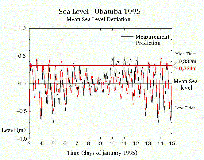
Fig 11 - Indicates the retro-predicted mean level of the syziges of
1995 to 2000 (0.334![]() 0.005 m) and the mean level of the syziges for the period, (0.332
0.005 m) and the mean level of the syziges for the period, (0.332![]() 0.007 m), obtained from the measurements. Mean Sea Level Heights of the
spring tides of 1831 were calculated by retro prediction, using the tidal
constants given by Mesquita & Harari (1983), for Ubatuba .
0.007 m), obtained from the measurements. Mean Sea Level Heights of the
spring tides of 1831 were calculated by retro prediction, using the tidal
constants given by Mesquita & Harari (1983), for Ubatuba .
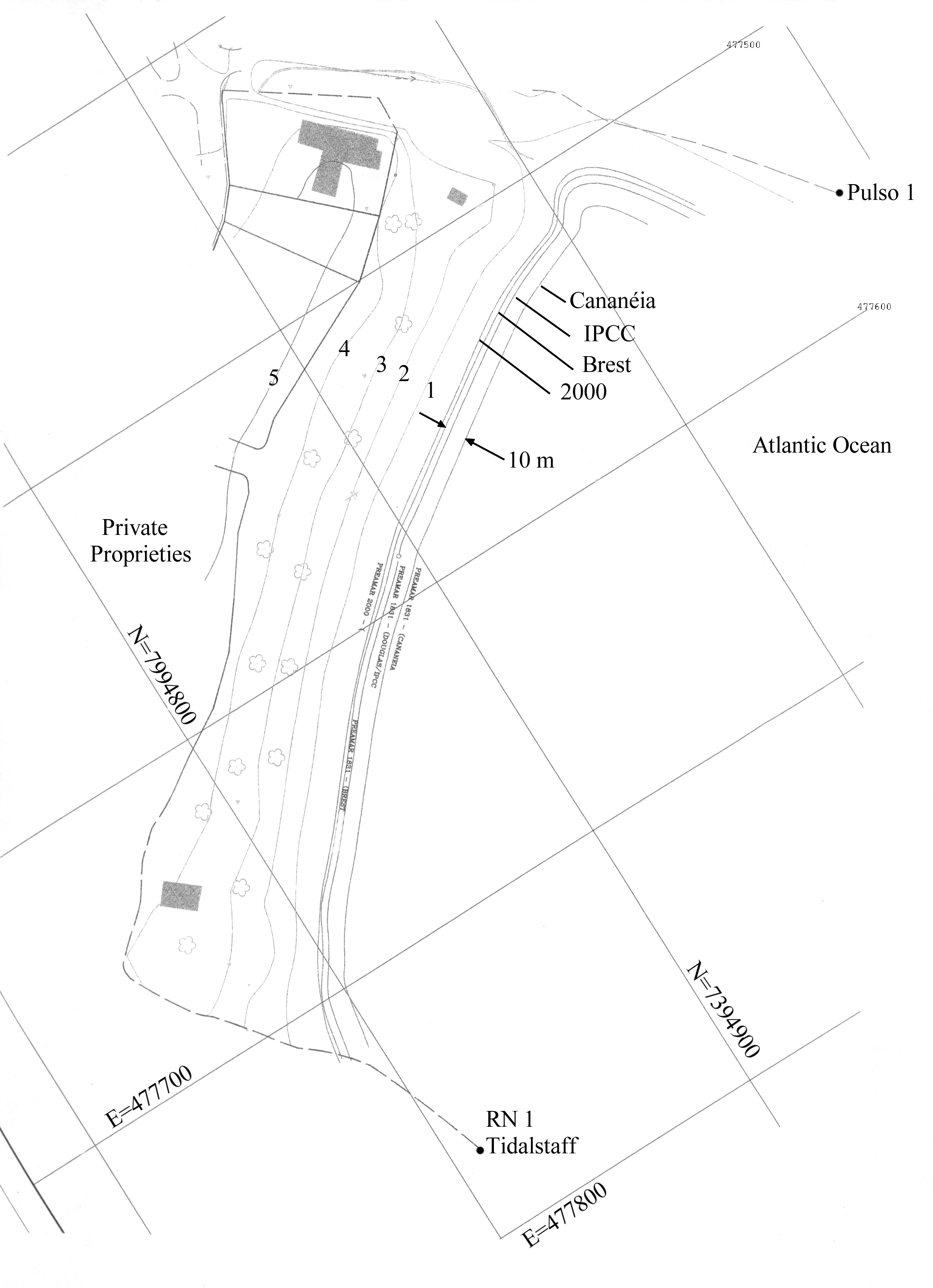
Fig 12 - Mean Sea Level Heights of Sygizes of "Praia do Pulso" of years 2000 and of 1831, calculated according to the hypotheses: Brest, IPCC and Cananéia. The line of Mean Sea Level Heights of 2000 was obtained from the measurements at Ubatuba station and the 1831 corresponding lines were drawn according to the hypotheses of Brest, Cananeia and IPCC. The horizontal distance between the external lines (Cananeia and Praia do Pulso 2000) of the set is nearly 10 m. From this estimate one sees that by taking any of the lines for the mean level of sygizes to start measuring 33m towards the continent horizontally that no one of them reaches the limit of the private properties.
Discussion
Is from the Brazil colony, in the XVIII century, the initial step of the Portuguese Crown relative to the constructions near the seashores that are related to the present regulations for the property of the Union land areas. Governmental taxes in 1846, now known by the name of "Laudemio", were applied to land areas called, in 1868, by the name "Terrenos de M arinha": the shore areas of free access of the population. All names were given in the Second Kingdom and still endure in the present days of Brazil Republic, SPU (1999).
The definition of "Terrenos de Marinha" happened during the years of Republic, with the Instruction 348 and the Decree N 9.760 firmly established the Mean Sea Level of High Waters of 1831 as the reference for the delimitation of the "Terrenos de Marinha" as properties of the Union.
In the period of 1820 to 1840, that includes the year 1831, the Relative Sea Level of Long Term (sea level measured along the regression line of the period) remained relatively constant and the Relative Sea Level of the year 1831,established as reference, complied satisfactorily with the function of a geodetic mark for the application of the Law 9.760.
In fact there was a small variation of the air temperature and a consequent small increase of the sea level, that started during the last 15.000 years, IGBP (1996), summarised in Mesquita (1998), which, however, did not produce any worry as it was small and difficult to measure.
At that time, in 1822, the basic tool for the analysis of Tides had been developed by JB Fourier, and the phenomenon of Tides had its understanding established in 1670 by Isack Newton. The industrial age then started and went through the 20th century, with increasing production of green house gases. The increase in temperature of the air heated the poles, producing the melting of the ice and consequent increase in relative sea level rise, followed by a crustal rebound in the polar areas. Peltier (2000).
In opposite direction of the crust rebound, consequent of a lesser amount of ice in the polar areas, is acting the variation of the earth's obliquity of the vector angular speed of the Earth, as pointed out by Chao (1999), making the tropics of Cancer and Capricorn to be closer to the equatorial belt and favouring the production of a new glaciation period, as the effect limits the solar radiation incidence into a smaller area, round the equatorial belt, during the seasonal cycle; effect that has a Milankovitch period of about 41K years, IGBP (2000).
In opposite direction walk also the two indices of measuring the sea level, as such, the Relative Sea Level of the Tropical area, where it increases, and the polar areas, where the Relative Sea Level is expected to diminish, probably due to post glacial rebound pointed out by Peltier, Mesquita (1994).
To establish with exactitude of what would be the winning cause, only measurements of the Absolute Sea Level in the tropics and polar areas, on how the adjustment is occurring, can certify. At the research stations of Ubatuba and Cananeia such studies are being made via GPS (Global Positioning System) vertical direction measurements and relative and absolute gravity measurements, Denizar (1999) and Franco (2000).
In spite these uncertainties is very much probable that the Relative Sea Level, not only in Cananeia, but all over the Brazilian coast may be rising at 41 cm/cty Mesquita, Harari & França (1996). This is sufficient for the establishment of fair procedures that would allow the application of the Law for the definition of the limits of the Union property, whatever comes to be the final result the winning push and pull cause of those measurements.
The legislator of 1946, when taking the relative sea level of 1831, as a geodetic mark, for that, did not take into account the knowledge produced by science during the period (1831 to 1946) that go from the phenomenon of the glaciation to the phenomenon of global warming, among others, which turn to mobile, the before taken as immovable properties of the Union that deals with the Law 9.670.
The procedures adopted in the present work admit such mobility and, through the variation of the Relative Sea Level, from the hypothesis of Brest, IPCC and Cananeia, take into account more important influences, which rely on the sea level of the period 1831 to 2003 for the determination of the level of reference of 1831 in Praia do Pulso the Law refers.
For that to be possible however, it was necessary the use the data of a permanent sea level station for the obtainment of the Long Term Relative Sea Level (LTRSL), as near as the station of the research station of Ubatuba, whose measurements allow also the materialisation of simultaneous Mean Relative Sea Level Heights of Syziges and the Long Term Relative Sea Level of the measurements taken at Praia do Pulso.
It was also necessary to certify that the seasonal, daily and diurnal variations of the sea level of the area where the Praia do Pulso is in, to be similar, so that that the hypothesis could be accepted and adopted for transferring these levels as shown in Mesquita,(2003). (See also www.mares.io.usp.br icon "Praias Arenosas" - Sandy Beaches).
Now days the National reference for geodesic measurements are no longer taken as the 1831 sea level of the port of Rio de Janeiro. The port of Imbituba, in the State of Santa Catarina, is the reference taken by the Brazilian Institute of Geography and Statistics (IBGE) for the purpose. It is not known how the sea level of Imbituba relates to the 1831 sea level of Rio de Janeiro that the law 9670 refers, but this is not an impediment for its application if one can count on the present procedures to estimate its position on the ground, all along the Brazilian coast.
Based on these procedures, Fig 12 indicates clearly that whichever are the hypothesis adopted, Brest, IPCC or Cananeia, the limits of the "Terrenos de Marinha" in Praia do Pulso, now determined, are well within the line of demarcation as the limit of 33m from the Mean High Waters of 1831 for the application of the terms of the Law number 9670 of 1946.
However such kind of accuracy in the demarcation of "Terrenos de Marinha" may not be occurring all along the Brazilian coast, as shown by the of Barra do UNA, Mesquita et al. (2002) (See also www.mares.io.usp.br icon aagn, edition 6(1)), and to allow similar demarcation in all beaches and ports of the coast, the upgrade of the sea level network may be required. The national network of sea level gauges was inactivated, years ago, and is necessary to re activate it for the purpose.
Conclusion
The measurement of the Relative Sea Level in Praia do Pulso (PP), referred to the Mean Relative Sea Level Heights of Sygizes of the year 1831, as established by the Law Number 9.760 of 1946, through plausible hypothesis on the variation of global relative sea level from 1831 to the present days, allowed the demarcation of the "Terrenos de Marinha"(Union Sea Land Property) in PP.
The sea level retro-prediction of the mean of high water for 1831, allowed its materialisation along the terms of the Law. The accuracy of the procedures of sea level transference from Ubatuba station to PP, based on geographical proximity of the localities, were assessed by parallel work of geometrical levelling. The levelling measurements were extended to the bench mark of Praia do Caçandoca, where the first IO-USP levelling work of the area was made in 1958, during the Geophysical year.
Three plausible and measurable hypotheses were used as follows:1) that the relative sea level in Praia do Pulso varied in the period of 1831 to 2003 at the same rate as the rate of variation of the relative sea level of the port of Brest, France; 2) that the relative sea level of PP varied at the same rate as the Global Relative Sea Level presently estimated by the Intergovernmental Panel for Climatic Changes (IPCC) and: 3) that the rate of variation is equal to the rate of variation registered till now for the relative sea level at the port of Cananeia.
The results indicate that for any of the above hypothesis, the limits of the "Terrenos de Marinha", in Praia do Pulso were obtained in accordance with the Law 9.760 and are entirely enclosed in the beach, not invading the private properties, as it was observed from similar measurements recently made in Barra do Una, in northern coast of the State of Sao Paulo, Brazil Mesquita et al (2002).
The discussion of results reveals the need for re activating the national net work of sea level gauges, bearing in mind the evidences of increasing Relative Mean Sea Level its consequent mobility all along the Brazilian coast and the need for an adequate definition of legal norms to face it and the global warming effects on sea level.
Acknowledgements
We are grateful to Mr Raimundo Antunes de Carvalho, Mr Arildo Fernandes de Morais and Mrs Maria Aparecida Simões, that helped with the field work in Praia do Pulso and to the local land lords who helped with the expenses.
References
-Blitzkow, D. (1998). Monitoramento das Condições Geodinâmicas dos Marégrafos de Cananeia e Ubatuba: Brasil, Lat (24 S). Afro-América GLOSS News. 3(1). 1998. Ver: www.mares.io.usp.br/aagn/
-Chao, B F. (1999). Concrete testimony to Milankovitch Cycle in Earth's Changing Obliquity. EOS Transactions Am. Geophys.Union. Vol (77) Number 44:433.
-Douglas, B C. (1991). Global Sea Level Rise. J. Geophys. Res. 96, No C4, 6981-6992. -EOS (1994). Solar Influences on Global Change Get their Day in the Sun. Trans. Ame. Geophys. Union. 75 (39): 449-451.
-Franco, A S, Mesquita, A R de. (1986). On Practical Uses f filtered Daily Sea Level. IHR (6) dois (2): 133-141.
-Franco, A S. (2000). Utilização do nível médio do Mar para fins Ambientais e Geodésicos. Afro-America GLOSS News. 4(1), 2000. Ver: www.mares.io.usp.br/aagn/
-IGBP. (1996). Global Network for Isotopes in Precipitation. (GNIPG). International Geosphere Biosphere Programme/ World Meteorological Organisation. 48p.
-França, C. A. de S. (2000).Contribuição ao Estudo da Variabilidade do Nível do Mar na Região Tropical Atlântica por Altimetria por Satélite TOPEX/POSEIDON e Modelagem Numérica. Tese de Doutorado. Instituto Oceanográfico da Universidade de São Paulo.SP.Br. 274p.
-Jose Antonio dos Santos. (1999). Instituto Nacional de Pesquisas Hidroviárias. Rua do Caju. Rio de Janeiro. RJ. (Comunicações Pessoais).
-Mesquita, A R de e Harari, J. (1983) Tides and Tide Gauges of Cananeia and Ubatuba - Brasil (Lat 24 50) Relat. Int.Inst. Oceanogr., Univ. S Paulo. SP.11, 1-12.
-Mesquita, A R de. (1998). O Programa IOUSP para o Global Change : Origem e Contribuições Int. Est. avanç. Univ. S Paulo. SP. Vol. (único) : 130-149.
-Mesquita, A R de. (1994). Variação do nível do Mar de Longo Termo. Inst. Est. avanç. Documentos, Série Ciências Ambientais. Vol (20) : 47-67.
-Mesquita, A R de, Harari, J. and França, C A S. (1996). Global Change in the South Atlantic: Decadal and Intradecadal Scales. An. Acad. Bras.Ci.,Vol (68) Supl I: 117-128.
-Mesquita, A. R. de, D. Blitzkow, C. A. S. França, J. L. A. Trabanco, M. A. Corrêa & M. Quandt Monteiro (2003).Nível Relativo do Mar de 1831 em Barra do Uma. Submitted, Brazilian Journal of Geophysics. See also http://www.mares.io.usp.br/aagn/51/una/una.htm.
-Mesquita, A. R. de. (2003)Sea Level Variations along the Brazilian Coast: A Short Review. Edtrs Klein,A. H. F. et al. In Proceedings of the Brazilian Symposium on Sandy Beaches. SI, Vol (35):21-31.
-Mesquita, A. R. de & França, C. A. S. (2001) Sumário
de Marés Oceânicas. (unpublicated manuscript) Lecture Notes
for GLOSS (1999) Training course São Paulo. see library of the Institute
of Oceanography - USP São Paulo Brazil
-Miniussi, I.C. (1963).Hidrografia. In: Levantamento Oceanográfico Meteorológico da Enseada do Mar Virado. Ubatuba. Estado de São Paulo Contrções avulsas,Inst oceanogr.USP.S.Paulo.SP. Vol(5):9-23.
-Peltier, W. R. (2000). Global Glacial Isostatic Adjustment and Modern Instrumental records of Relative Sea Level History. In Sea Level Rise,
- Occhipinti, A. G. (1963). Potencial de Poluição Atmosférica. In Levantamento Oceanográfico Meteorológico da Enseada do Mar Virado. Ubatuba. Estado de São Paulo.SPContrções Avulsas.Inst.oceanogr.Univ.S. Paulo.SP No cinco: 71-118.
-PSMSL (Permanent Service for the Mean Sea Level) Inglaterra. http://www.pol.ac.uk/psmsl/programmes/gloss/info.html - IAPSO (International Association for the Physical Sciences of the Oceans). Bidston, Birkenhead. POL (Proudman Oceanographic Laboratory). Inglaterra. Douglas, B. C. Kearney, M.S e Leatherman, S. P.)International Geophysical Series Vol(75):65-95.
- SPU (1999). Serviço do Patrimônio da União. Ministério da Fazenda da República do Brasil. Cronologia Básica da Legislação Patrimonial.1p