Joseph Harari 1 & Ricardo de Camargo 2
1 Institute of Oceanography
joharari@usp.br
2 Institute of Astronomy, Geophysics and Atmospheric Sciences
ricamarg@model.iag.usp.br
University of Sao Paulo Sao Paulo - Brazil
In the central part of Sao Paulo State coastal area are situated the cities of Santos, Sao Vicente and Cubatao, with important resorts and large scale economical activities, especially in the industries of Cubatao and the Port of Santos, the biggest port of South America. Besides, the estuary formed by the inner areas, including the Channel of Sao Vicente, requires permanent monitoring of its environmental conditions.
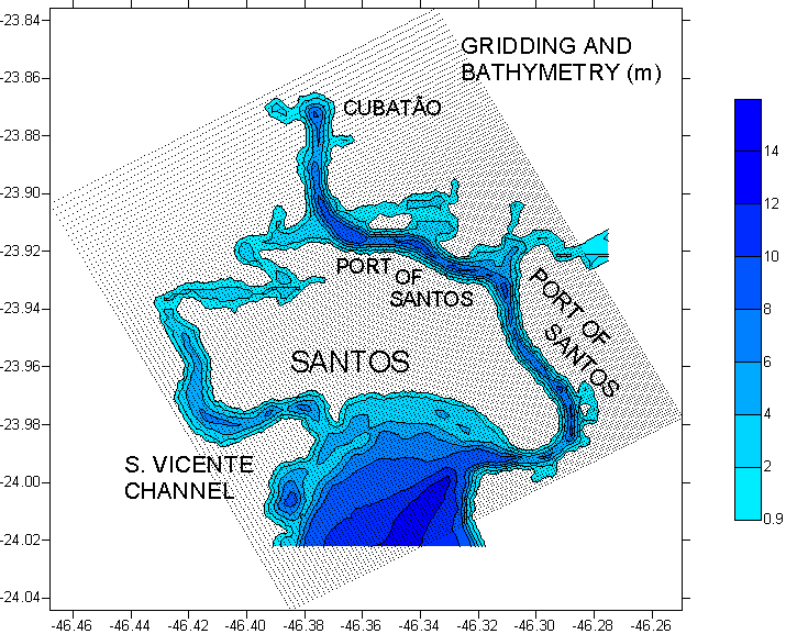
This publication presents a numerical study of the circulation in the
coastal region, which has a quite complex bathymetry, especially in the
Port of Santos, which dredged Channel has a minimum depth of about 12 m
in an extension of more than 10 km (see Figure 1). This figure also presents
the grid used in the hydrodynamical numerical simulations, formed by 146
x 132 horizontal points. The mesh has variable spacing with increased resolution
in its central part, reaching 100 m in the area of the Port.
The circulation model is based on the POM - Princeton Ocean Model, which makes use of sigma vertical coordinates and a second order turbulent closure scheme (Blumberg & Mellor, 1987). The model run with 11 sigma levels and boundary conditions specified by a coarser hydrodynamical numerical model of the coastal region, corresponding to the amplitudes and phases of tidal constituents Q1, O1, P1, K1, N2, M2, S2, K2 and M3 (Harari & Camargo, 1998; Harari, Camargo & Cacciari, 1999). Mean sea level variations at the boundaries generated by remote winds are computed by a large-scale hydrodynamical model that covers the Southwest Atlantic (www.surge.iag.usp.br). Surface winds are provided by predictions and reanalysis of NCEP - National Center for Environmental Prediction (NOAA / USA), interpolated for the model grid points (www.cdc.noaa.gov).
Fig. 1 - Region of study, its bathymetry and model grid.
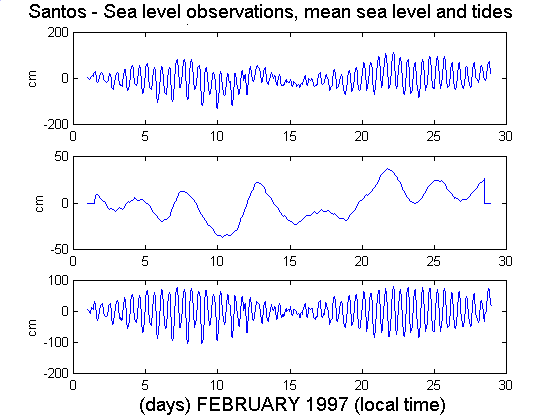
Fig. 2 - Sea surface level, mean sea level and tides in Santos (February 1997).
The model run from 18 to 22 February 1997, when a cold front incursion caused a significant increase of the mean sea level in a period of spring tides. Figure 2 shows that, in this period, the mean sea level reached a maximum value of 36.7 cm, the tide 76.8 cm and the observed sea level 112.6 cm (values above the monthly mean sea level).
Two runs of the model were performed, considering the forcing of tides, winds and mean sea level variations in the first one and only tides in the second. However, in the first run, observed mean sea level variations in this area were specified as boundary conditions, instead of the results of the coarser model that covers the Southwest Atlantic. The model computations fitted observations of the sea surface level and predicted tides relative to the tidal station of Alamoa - located at 23° 55.2'S 46° 22.6'W.
Examples of the model outputs are shown on Figures 3 and 4, relative to 03:00 GMT of 21 February 1997, with flooding currents. Figure 5 presents the difference of the model runs, corresponding thus (approximately) to the circulation due to winds and mean sea level variations.
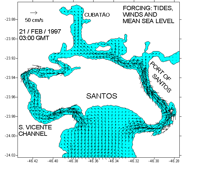
Fig. 3 - Coastal currents due to tides, winds and mean sea level variations.
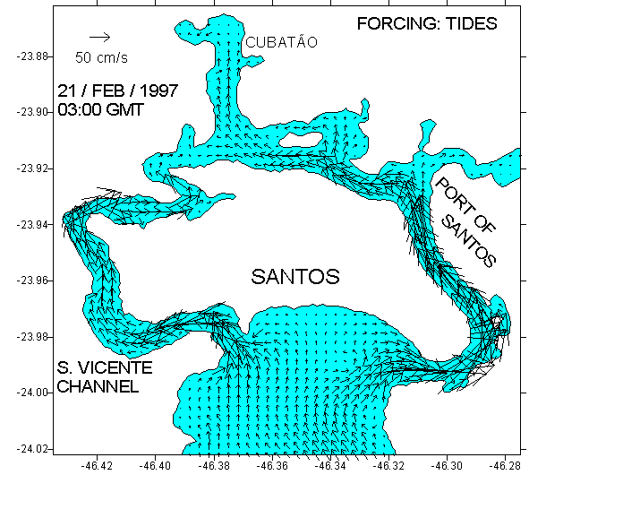
Fig. 4 - Coastal currents due to tides.
Figures 3 and 4 clearly show that the tides are the main contributors to the coastal circulation, especially along the Channel of Sao Vicente and the Port of Santos. Figure 5 indicates that, although smaller, the currents generated by local winds and mean sea level variations (which represent the effects of remote winds) are still significant, mostly in the Bay of Santos (note that the vectors scale of this figure is changed relative to the former ones). An interesting feature shown by the circulation due to meteorological effects is the formation of eddies on the eastern part of the bay, especially at the mouth of the Channel of the Port, due to strong bathymetric gradients (as shown on Figure 1).
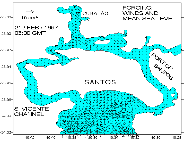
Fig. 5 - Coastal currents due to winds and mean sea level variations.
The implemented modeling has given support to many researches and technical activities in this coastal region, such as the determination of nutrients distribution and the dispersion of oils and other pollutants.
Future improvements in this research will consider the additional effects of temperature and salinity as well river discharges, which may become an important part of the circulation in some regions inside the estuarine area.
REFERENCES
Blumberg, A. F. & Mellor, G. L. - 1987 - "A description of a three dimensional coastal ocean circulation model". In: N. S. Heaps (Ed.), Coastal and Estuarine Sciences 4: Three-dimensional Coastal Ocean Models - American Geophysical Union, pp. 1-16.
Harari, J. & Camargo, R. - 1998 - "Modelagem numérica da região costeira de Santos (SP): circulação de maré" - Revista Brasileira de Oceanografia, vol. 46 (2), p. 135 - 156.
Harari, J. & Camargo, R. & Cacciari, P. L. - 1999 - "Resultados de modelagem numérica hidrodinâmica em simulações tridimensionais das correntes de maré na Baixada Santista" - Revista Brasileira de Recursos Hídricos, vol. 5, n° 2, p. 71 - 87.
ACKNOWLEDGMENTS
We are grateful to CNPq - Conselho Nacional de Desenvolvimento Científico e Tecnológico (National Council for Scientific and Technological Development) for the support of this research and to FUNDESPA - Fundação de Estudos e Pesquisas Aquáticas (Foundation for Aquatic Studies and Researches) for providing equipments and data (Project Automated system for collecting environmental data in the Port of Santos - 1996 / 1998).