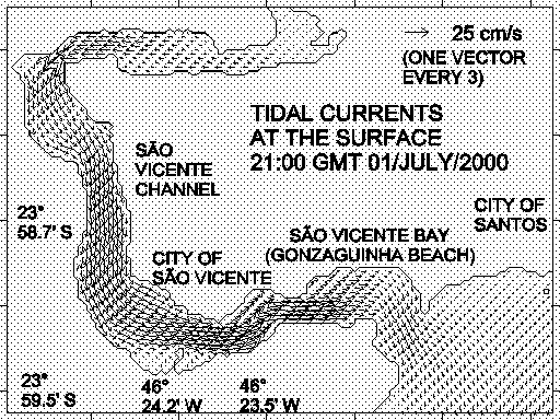
Fig. 1 - Tidal currents at the surface given by the hydrodynamical
numerical model of São Vicente Channel.
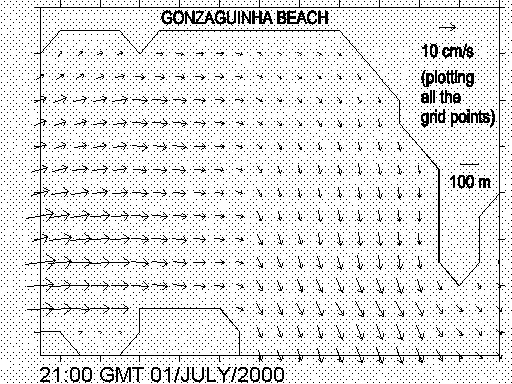
Fig. 2 - Tidal currents in the Bay of São Vicente near to "Gonzaguinha Beach".
Joseph Harari 1 & Ricardo de Camargo 2
1 Institute of Oceanography
2 Institute of Astronomy and Geophysics
University of Sao Paulo
Sao Paulo - Brazil
The Bay and Beaches of São Vicente (23° 58'; S 46° 22'; W) are important tourist points of São Paulo State, requiring thus the maintenance of their environmental conditions, which is the objective of a Project submitted to São Vicente Authorities. The main motivation of the Project is the need of recovering the Beaches and the Bay of São Vicente and keep them stable for a long time period.
The first stage of the project consists on recovering historical recordsand establishing a technical support for long term solutions. At the endof the project, the study should lead to the choice of the best engineeringoptions suitable to solve the actual problem.
The project is composed by five modules, given below with the respectiveprincipal
investigators:
| 1 | Atmospheric circulation | Dr. Ricardo de Camargo |
| 2 | Mean sea level and coastal circulation | Dr. Afranio R. de Mesquita |
| 3 | Propagation of surface waves (sea state) | Dr. Paolo Alfredini |
| 4 | Morphologic evolution of the beaches | Dr. Moysés G. Tessler |
| 5 | Implementation of numerical models | Dr. Joseph Harari |
Each module has the following objectives and methodology:
1 - Atmospheric circulation: will analyse local winds in the Bay of São Vicente and surroundings, especially the characteristics of its synoptic component and the diurnal cycle. This module will allow to estimate the local influences in the field of surface winds and give information to the other modules, such as the ones of coastal circulation and sea state. In order to perform these studies, the Regional Atmospheric Modeling System (RAMS) will assimilate meteorological fields in global scale in order tocompute local circulations in grids with horizontal resolution of 5 Km to1 Km.
2 - Mean sea level and coastal circulation: will provide the analysis of the tides and mean sea level variabilities, in order to compute the amplitudes and phases of the tidal constituents and the diurnal, monthly and seasonal variabilities of the mean sea level (including the estimation of extreme sea levels and their periods of recurrence). Concerning the methodology of data processing, sea level measurements in the area will be analysed through the Harmonic Method of Tidal Analysis and submitted to statistical analysis, including correlations with wind data.
3 - Propagation of surface waves (sea state): the predominant waves from SE, S and SW are modified by São Vicente Bay morphology so the module aims to determine the standards of wave propagations, breaking zones and correspondent sediment transports. The methodology to be used considers statistical analysis of the available surface waves data, building the orthogonals of the waves propagation (from the deeper to the shallower coastal areas), establishing the degree of exposure of the beaches, positioning of the breaking zones and estimation of sediment transports though empirical expressions.
4 - Morphologic evolution of the beaches: has the objectiveof characterizing the beaches modifications (through erosion and depositions) in several time scales - daily and monthly (due to the tides), annual and those of longer time periods (associated to seasonal and long term mean sea level variations). The module has also the aim of identifying other effects that control the coastal processes, such as climate, coastal vegetation,wind regimes, coastal currents, surface waves, etc ; Cartographicand aerophotographic documents will be analysed and reduced to a common scale,in order to allow the comparison of the beaches extensions and estimate theirevolution in time.
5 - Implementation of numerical models: numerical simulations of currents, surface waves, dispersion of substances and sediment transports will allow to understand the behavior of the coastal area and give the engineering options to recover the beaches and keep the environmental stability. Thecirculation model is based on the POM - Princeton Ocean Model, which makesuse of sigma vertical coordinates; the wave model is the SWAN - SimulatingWaves Nearshore, a third generation numerical wave model; the dispersionmodel has two possible solutions, based on finite differences of the advection - diffusion - decay equation and the Lagrangean - random walkof particles methods; finally, the sediment transport model is an extensionof the dispersion model, including sediments characteristics.
The project is planned to be completed until the end of 2003. At the present, preliminary results have been obtained, as will be shown below.
Figure 1 presents model results in the Southern part of São Vicente Channel, considering the tidal circulation only, with strong ebbing currents at the surface, in a period of spring tides, with values up to 37.8 cm/sin areas where the Channel becomes narrow. The computational mesh of São Vicente Channel has a horizontal spacing of 100 m and 11 vertical levels(Fig. 1 contains one vector every 03 grid points). The model run with boundaryconditions specified by a coarser hydrodynamical numerical model of the coastalarea, corresponding to the amplitudes and phases of tidal constituents Q1,O1, P1, K1, N2, M2, S2, K2 and M3 (Harari & Camargo, 1998; Harari, Camargo& Cacciari, 1999). Figure 2 shows the same model results, but specificallyin the Bay of São Vicente near to "Gonzaguinha Beach", the area of main interest of the research project, in a plot that includesall the computed currents. The model results show weak tidal currents inthe internal part of the Bay of São Vicente, probably not sufficientlycontributing to sediment transports (and beach filling).
Fig. 1 - Tidal currents at the surface given by the hydrodynamical
numerical model of São Vicente Channel.
Fig. 2 - Tidal currents in the Bay of São Vicente near to "Gonzaguinha Beach".
The preliminary analyses and modeling have proven the importance of thescientific researches, which are expected to lead to very useful resultsfor both the local communities and tourists.
REFERENCES
Harari, J. & Camargo, R. - 1998 - "Modelagem numérica da região costeira de Santos (SP): circulação de maré" - Revista Brasileira de Oceanografia, vol. 46 (2), p. 135 - 156.
Harari, J. & Camargo, R. & Cacciari, P. L. - 1999 - &
"Resultados de modelagem numérica hidrodinâmica em simulações
tridimensionais das correntes de maré na Baixada Santista" - Revista
Brasileira de Recursos Hídricos, vol. 5, n° 2, p. 71 - 87.